Kia ora and welcome to the September 2017 update from the Transmission Gully team.
Good progress continues across the 27 kilometre route despite a wetter than anticipated summer and recent winter weather slowing progress in some areas of the project.
A number of bridges are starting to take shape, with construction well underway, including extensive stone column foundation treatments to lessen liquefaction at Lanes Flat and Mackays Crossing during an earthquake. This technique will improve the motorway’s resilience in a demanding environment. Preparations are also underway for the summer season of bulk earthworks. The big machines are on site and rearing to go.
Here’s an update from the team about what’s been happening during winter on the Transmission Gully motorway project, and also what’s coming up.
At the northern end of the project, work continues to move utilities such as gas pipelines and water mains ahead of the motorway’s construction. Last month the gas main was switched to a new pipeline, allowing construction to start on the final foundation treatments just west of State Highway 1 near Mackays Crossing.
Excavation works for a bridge to provide access to properties on the eastern side of the motorway have started and foundation works for the Wainui Stream crossing are complete.
Earthworks here continue at pace with our teams working day and night.
In the Te Puka Valley, we’re using ‘soil nails’ as part of construction to strengthen steep slopes. This construction technique involves placing multiple reinforcing rods at an angle into the soil to stabilise the finished slope.
Temporary stream diversion works are now complete for Horokiri Stream, and construction of the permanent stream diversion is underway. Temporary diversion works are also close to completion for Te Puka Stream.
Around Pauatahanui work has focussed on connecting the access road between State Highway 58 and Battle Hill. Once the final few hundred metres of track establishment work is complete, the access road will allow our teams to drive along the full alignment.
Works on the bridges that will form part of the new State Highway 58 Interchange at Lanes Flat are tracking well, with the stone columns for the foundations for three of the bridges now complete. Stone columns are a ground improvement technique used in areas that are prone to earthquake liquefaction or flooding. Using an excavator with a vibrating probe, stone is fed into the ground to create a vertical column that provides an improved drainage path.
Behind Whitby, our construction teams have been hard at work relocating utilities. A number of precast culverts are now in place for the gas and water pipes that will cross under the motorway close to the James Cook Interchange.
At the site of the Cannons Creek bridge, works are ramping up on the project’s largest structure. Excavation for the bridge’s pier foundations is well advanced and is expected to be finished at the end of September. Once complete, the team can start building up, instead of digging down! Piling for the abutments (which support the bridge girders at both ends to prevent it from moving in an earthquake and also transfer the loads of the bridge into the ground) is now complete, and fabrication of the bridge’s huge structural steel girders is underway in Napier.
Over the coming months some 7,000 cubic metres of concrete will be poured to form the two main support piers – standing approximately 60 metres above the valley floor, the piers are just 13 metres shorter than Wellington’s State Insurance Building.


Project Engineer Nick Myers-Kay showing detailed designs for the bridge’s pier foundations and columns.

The 60 metre long launching nose, weighing 240 tonnes, connects to the girders and helps guide the bridge across the valley.
Prefabricated bridge girder sections, due to arrive from Napier in March 2018, will mark the start of the ‘launch sequence’. This involves assembling the bridge in four stages on land, and then each section will be pulled out or ‘launched’ over the valley onto each of the piers.
Cannons Creek bridge by the numbers:
The team have completed 600 metres of clearing works along the Waitangirua link road alignment in preparation for the earthworks. The construction compound, a sediment retention pond and site access at Waitangirua is now complete and we’re now underway with constructing the second sediment retention pond further up the route.
Works to realign existing underground services continue on Warspite Avenue around the Niagara Street intersection. We expect these works to take the next few months to complete, ahead of the road works that are needed to construct the new Waitangirua Link Road traffic signalised intersection.
The link roads are being constructed by CPB HEB JV under a separate contract for Porirua City Council, and will provide the community with access to the new Transmission Gully motorway once open in 2020.
Visit Porirua City Council’s website(external link) to find out more about the link roads project.
At the southern end of the project, works in the median on State Highway 1 north of Linden are now complete. The traffic lanes have shifted to enable work on the new bridge over Collins Avenue to start. Please drive with care and watch for the latest messages on the variable message signs.
Clearing the Ranui pine plantation has enabled significant progress on the earthworks including piling for the abutments of the bridges that make up the Kenepuru Interchange, along with the substructure (which supports the bridge and transfers the load of the bridge to the foundations) for the new Collins Avenue bridge. Drainage works have also started along Little Collins Street and Tremewan Street.
Read our story Innovative work at Kenepuru to find out more about the work we’re doing at the southern end of the project.
With spring upon us and summer just around the corner, the team is getting ready for another huge season of bulk earthworks. Between September 2017 and May 2018 we’ll be focusing on:
Heavily-reinforced concrete columns rising out of earthworks on the Kenepuru-Linden stretch of State Highway 1 are early chapters in one of Transmission Gully motorway’s more technical stories.
The columns are bridge piles and a nearby collection of large steel casings ‘pile sleeves’ mark the start of the works to build the new Kenepuru Interchange.
Zone Manager Ben Patrick says the bridge piles, some over 30 metres long, will have air voids between them and the surrounding ground and will be encased in ‘cascading sleeves’ with larger diameters at the top and smaller at the bottom, allowing lateral movement of the piles to accommodate earthquake shaking. In effect the ground can move but the bridge will stay upright.
Adding to the site’s complexity, a temporary bridge structure has been installed across the Kenepuru Stream for workers’ access and as a building platform for the central pier of the bridge that will cross the stream and the North Island Main Trunk railway line.
Many people don’t realise the existing Collins Avenue bridge at Linden is in fact two separate bridges side-by-side. The two bridges carry north and southbound traffic on State Highway 1 over Collins Avenue, and allow traffic access underneath the existing motorway along Collins Avenue.
The new bridge is being built in stages around the old one. "We're going to demolish each section at different times, while keeping the traffic flowing," says Ben.
Here’s a breakdown of what you can expect to see over the coming years as construction of the Kenepuru Interchange and Collins Avenue bridge ramp up.
In September, southbound State Highway 1 traffic south of Collins Avenue shifted onto the new road layout in the middle of the highway. This allows our teams to work safely on the side of the motorway building retaining walls and installing longitudinal drainage, to be followed by embankment and pavement construction.
Widening works to move northbound traffic towards the median of State Highway 1 are also set to be complete during September, which will allow our teams to start construction of the headstock for one of the bridges on the Kenepuru Link Road that makes up part of the Kenepuru Interchange. A ‘headstock’ is a part of a bridge which transfers loads from the superstructure (deck which carries traffic) to the piers.
In October, further median widening works will take place to move northbound traffic closer to the middle of the highway, to allow for headstock construction for another of the bridges that make up the Kenepuru Interchange.
In mid-2018, southbound traffic will shift onto the newly constructed stage 1 section of the Collins Avenue bridge, to allow demolition of the existing southbound bridge and construction of stage 2 to start.
North of Collins Avenue, northbound traffic will shift over to the left so our teams can work in the middle of the highway on construction of the central piers for two of the bridges that are part of the Kenepuru Interchange.
In early 2019, northbound traffic will be moved onto the new stage 2 section of the Collins Avenue bridge, which will allow us to demolish the existing northbound bridge and construct stage 3 of the new bridge.
In early 2020, both north and southbound traffic will be moved onto the permanent alignment.
Construction Project Director Boyd Knights asks people to be patient during construction. “One of the main challenges for our construction teams is working so close to suburban streets and existing traffic. As much as possible, any lane closures will happen at night and there is a constant need, for safety reasons, for motorists to follow all reduced speed limits and public-access restrictions to the site.”
We thank you for your patience and understanding so far, and if you have any questions or concerns, please contact us at any time on 0800 84 4636 (0800 TG INFO), or email us at info@tg.co.nz.
Watch the animated fly-through video below for the Kenepuru Interchange.
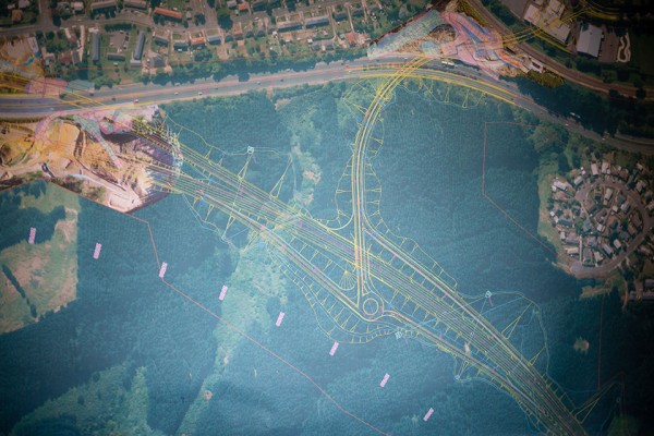
Aerial design map showing the Kenepuru Interchange and tie in to State Highway 1.
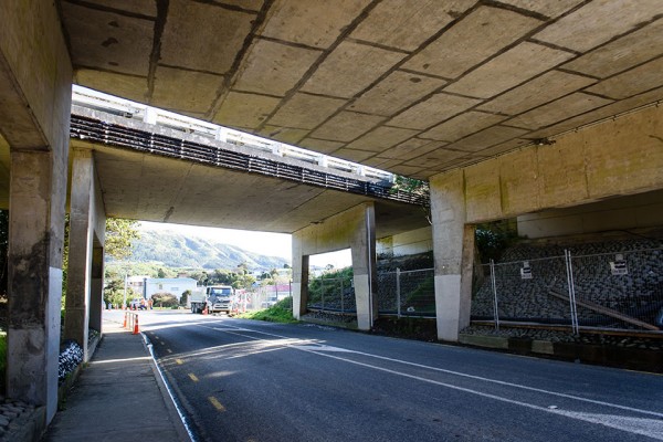
View under the Collins Avenue bridge, which is being replaced with a new bridge.

View looking west over the Kenepuru Interchange works with steel pile casings in the foreground.
The recent discovery of a metal sphere, thought to be a ship’s cannonball, has reignited interest in the history of Transmission Gully.
The ball, just over 25 centimetres in diameter, weighing about 53 kilograms and found by workers in the headwaters of the Horokiri Stream has been the subject of intense research by Project Archaeologist Mary O’Keeffe. “It has the exact dimensions of balls used in huge cannons mounted on ships around the mid-nineteenth century,” she says. “How it ended up in the creek is a mystery.”
Initial speculation had the find dating back to 1846, when Crown troops attacked the pā (fortified villages) of Ngāti Toa leader Te Rangihaeata and his people at Matai Taua (Pauatahanui) and Battle Hill in the valley.
“But the cannonball was found some two kilometres from Battle Hill and there are detailed records of the guns used there. They fired balls only around a tenth of the weight of this one”, Mary says.
Strict protocols are in place for the Transmission Gully motorway project for suspected pre-European sites, with examples of local historic finds pictured at induction courses for all workers. Machinery operators are required to stop immediately if an unusual item is found or even if a patch of ground looks different to surrounding areas, and to call the project’s environmental team.
Construction Project Director Boyd Knights says great care was taken when the cannonball was first found. “The team knew exactly what to do – an exclusion zone was set up and Mary and our Ngāti Toa contact were called in immediately.” Police and an army bomb disposal squad were also brought in, to ensure there was no risk of the item exploding. “Workers safety is our top priority, and until the item could be identified, staff were required to move out of the exclusion zone” says Boyd. Once the cannonball was deemed safe, it was documented and removed from the Horokiri Stream, and construction teams returned to work.
A half-finished argillite adze was also unearthed recently just south of Mackays Crossing, with the stone likely to have come from the Nelson-Marlborough area. Mary says that while this and other sites had yet to be dated, the adze was of a type that could go back to the sixteenth century.
“Archaeological sites often don’t include large artefacts but are rich because of the story they could tell,” says Mary. Eighteen middens and two ovens have been discovered so far. “It might start with a little pile of scruffy shells but it tells us what people were eating, where they were living, whether it was a seasonal camp and even if this was a family group or larger.” So far, the sites uncovered have provided evidence of “small groups of mobile people”.
Transmission Gully archaeology discoveries have been compared to others around New Zealand and to similar Polynesian coastal settlements in places like Hawaii, Tahiti and Easter Island. “In effect, these local sites are adding to the history of the entire Pacific Ocean, and that’s a third of the planet.”
Te Rūnanga O Toa Rangātira Chairperson Te Taku Parai says Transmission Gully was an important Māori trading route linking the Kapiti Coast, Porirua Basin and Wellington, especially via the Wainui Saddle and Horokiri Valley.
It became a key site also for the political struggle between Ngāti Toa’s leadership and Governor George Grey, who was seeking land for European settlers. “Grey wanted to get Te Rauparaha and Te Rangihaeata out of the picture so he could put pressure on second-tier chiefs to sign.” Te Rauparaha was captured at Plimmerton and then an armada of small boats, including a longboat with guns, sent to Pauatahanui. Written records tell of canister shot fired into bushes below Matai Taua and a brass gun bursting, burning an officer. Later two light mortars were dragged inland to Battle Hill.
Taku says oral history supported the view that small, ineffective cannons were used by Crown forces. “Our people were laughing and heckling because shots were dropping about 100 metres too short.” After just a handful of casualties on both sides, Te Rangihaeata escaped with the bulk of his followers up the valley and over ridges to Poroutawhao, just north of the present town of Levin.
The cannonball is likely to end up in Porirua’s Pātaka Museum and Ngāti Toa will be consulted about a home for the adze.


The Transmission Gully project team were proud to be involved in the 2017 IPENZ Week of Engineering, which ran from 31 July to 5 August. This series of events across the country aims to inspire and inform young people interested in pursuing a career in engineering.
As part of this, a group of local Porirua College Year 12 and 13 students spent the day touring the Transmission Gully project site and talking with our civil and structural engineers along the way about what led them into their career choice and what it means to them to be an engineer.
We also took part in the successful Engineering Expo held at Te Papa on 5 August. To find out more about IPENZ and the next Week of Engineering visit their website at www.IPENZ.org.nz(external link) or www.weekofengineering.co.nz(external link)


The Transmission Gully motorway mobile visitor centre has set up on the Wellington waterfront to provide Wellingtonians with a glimpse into the construction of the new 27 kilometre motorway that is taking shape to the north of the city.
Housed in a 20 foot container, the visitor centre has been designed to be transported around the region to provide information for communities along the route as well as all Wellington residents. It includes an animated fly-through of the new motorway, photos of construction progress, and a series of information panels about the project. The exterior features a specially commissioned mural painted by local Porirua artist Anthony June (Antz).
Transmission Gully motorway Construction Project Director, Boyd Knights says the visitor centre has been a popular source of project information for the community during its stay in Porirua and he expects it will receive a steady flow of visitors while on the Wellington waterfront.
“Much of the project is progressing out of public sight so the mobile visitor centre is a great way for people across the region to learn more about how we’re constructing the new motorway and our keeping up with our progress,” says Boyd.
The visitor centre is located next to Te Papa in Circa Square until the end of September and is open Monday to Friday from 10.00am – 4.00pm.


The mobile visitor centre located next to Te Papa in Circa Square.
Don’t forget to tell your friends and family to signup(external link) to receive the latest project news.
You can also visit our video and gallery pages showing construction progress and regular construction updates.
We hope you enjoy reading these updates, and we’d love to hear from you. If you have any questions, comments or story suggestions, you can email them to info@tg.co.nz.


